Rhode Island destinations, parks and attractions
Are you going on a road trip to Rhode Island, looking for tips about the destinations so you and your party can enjoy it, be comfortable and not spend a fortune?
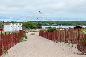
Here are some of the top destinations in Rhode Island and tips about visiting them. For Rhode Island beaches, click here.
National parks and monuments in Rhode Island
- Blackstone River Valley National Historic Park,
RI,MA.
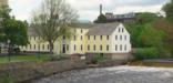
The Blackstone River powered America's entry into the Age of Industry. The success of Samuel Slater's cotton spinning mill in Pawtucket, RI touched off a chain reaction that changed how people worked and where they lived, and continues to reverberate across the nation to this day. Come visit and see how this revolution transformed the landscape of the Blackstone Valley and then the United States.
- Roger Williams National Memorial,
Providence, RI.
Roger Williams National Memorial commemorates the life of the founder of Rhode Island and a champion of the ideal of religious freedom. Williams, banished from Massachusetts for his beliefs, founded Providence in 1636. This colony served as a refuge where all could come to worship as their conscience dictated without interference from the state.

- Touro Synagogue National Historic Site,
Newport, RI.
Touro Synagogue, a building of exquisite beauty and design, steeped in history and ideals, and one of the most historically significant Jewish buildings in America, was designated a National Historic Site in 1946. Dedicated in 1763, it still serves an active congregation and each year greets over 30,000 visitors who come to see the magnificent interior and hear its remarkable story.

- Washington-Rochambeau Revolutionary Route National Historic Trail, MA,RI,CT,NY,NJ,PA,DE,MD,VA,DC.
In 1781, General Rochambeau’s French Army joined forces with General Washington’s Continental Army to fight the British Army in Yorktown, Virginia. With the French Navy in support, the allied armies moved hundreds of miles to become the largest troop movement of the American Revolution. The effort and cooperation between the two sides led to a victory at Yorktown and secured American independence.

Rhode Island State parks and historic sites
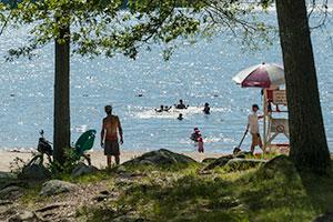
State Beach Parking - Check here for the near real-time status of parking lots at our busiest state beaches. Get A State Beach Pass
RI State Parks - Rhode Island's network of historic state parks attracts upwards of nine million visitors each year and hosts high-profile national and international events such as the Newport Jazz Festival, Newport Folk Festival, and Volvo Ocean Race.
- Beavertail State Park - Map. Beavertail Road, Jamestown. With its historic lighthouse and scenic coastline, Beavertail State Park is one of the most popular parks for sightseeing, picnicking, and saltwater fishing.
- Brenton Point State Park - Map. Ocean Drive, Newport. Occupying the former grounds of one of Newport's grandest estates, Brenton Point State Park affords its visitors spectacular ocean views.
- Burlingame State Park - Map. Sanctuary Road, Charlestown. This popular freshwater swimming area on Watchaug Pond offers picnic area, beach, and a nearby boat launch for boating and fishing.
- Colt State Park - Map. Route 114, Bristol. Colt State Park is often referred to as the 'Gem' of the State Parks System. The entire western border of the park is an open panorama onto Narragansett Bay.
- Fort Adams State Park - Map. Harrison Avenue, Newport. Situated at the mouth of the Newport Harbor, Fort Adams State Park offers an exceptional panoramic view of both Newport Harbor and the East Passage of Narragansett Bay.
- Fort Wetherill State Park - Map. Fort Wetherill Road, Jamestown. Situated upon 100 foot high granite cliffs, Fort Wetherill State Park is known for its spectacular views is a popular location for family and group picnicking, scuba diving, boating, fishing, and hiking.
- Goddard Memorial State Park and Goddard Memorial State Golf Course - Map. Ives Road, Warwick. The park offers spacious lawns, fields, and forested areas that feature a nine hole golf course, bridle trails, picnic tables, game fields, and a performing arts center
- Haines Memorial State Park - Map. Rte. 103, East Providence. A popular stop on the East Bay Bike Path, Haines Memorial State Park is known for its picnic groves with fireplaces built by the Civilian Conservation Corps in the 1930s.
- Lincoln Woods State Park - Map. 2 Manchester Print Works Road, Lincoln. Visitors can enjoy swimming at the freshwater beach, trout fishing, playing ball, hiking, jogging, horseback riding, bouldering, or just relaxing under a shade tree.
- Pulaski State Park And Recreational Area - Map. 151 Pulaski Road, Chepachet. From the first class trout fishing, to enjoying a picnic, a short hike, or a cool swim in Peck Pond, to cross-country skiing, Pulaski provides year round enjoyment for all ages.
- Rocky Point State Park - Map. 1 Rocky Point Ave, Warwick. As the state's newest coastal state park, visitors can enjoy the property they once made so many memories at, while younger generations of park-goers can make new ones.
- Snake Den State Park - Map. Route 6, Johnston. The 1,000 acre undeveloped property boasts self-guided walking trails, beautiful trees, flowers, plants, and working farm as well. The foliage is something to behold in the fall.
Rhode Island Seasons, bugs, topography and climate
Rhode Island has humid, warm summers and cold, less humid winters. The lowest recorded temperature in Rhode Island was −23 °F (−31 °C) on February 5, 1996, in Greene. Monthly average temperatures range from a high of 83 °F (28 °C) to a low of 20 °F (−7 °C).!
Rhode Island Camping tips
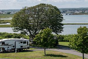
Rhode Island DEM's Division of Parks and Recreation manages 8,200 acres of land, including parks, beaches, campgrounds, bike paths, historic sites, picnic areas, trails, athletic fields, and fishing access.
There are both state parks and private campgrounds in Rhode Island.
RI State Campgrounds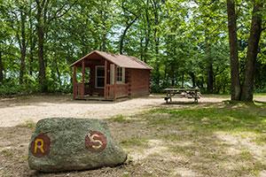
Burlingame
1 Burlingame Park Road, Charlestown
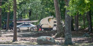
Situated next to Watchaug Pond, this spacious campground features 700 rustic campsites, as well as 20 rustic cabins. Enjoy conveniently located restrooms with shower facilities, playground, naturalist center, arcade, freshwater beach, boat ramp, canoe rentals, and hiking trails.
Charlestown Breachway
Charlestown Beach Road, Charlestown
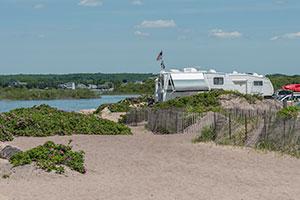
Camp along the breachway with spectacular ocean views and some of Rhode Island's best saltwater fishing. Walking distance from lifeguarded beach. Campground accommodates 75 self-contained RVs. No tents or pop-ups. Boat launch on site with limited parking.
East Beach
East Beach Road, Charlestown
Specialty camping at East Beach is offered in two areas which contain ten sites each. East Beach is one of the least developed of the Rhode Island state beaches, with limited parking and a half-dozen changing rooms. Nonetheless, it is one of Rhode Island’s spectacular seaside treasures. Campsites can only be accessed by 4-wheel drive vehicles.
Fishermen's Memorial
1011 Point Judith Rd., Narragansett
Tent and RV camping in a "seaside village" atmosphere, complete with neatly trimmed grass, tree lined paths and activities for the entire family, including basketball, tennis, horseshoe courts and a children's playground. Close proximity to state beaches, including Scarborough, Roger Wheeler, and Salty Brine, and one mile to the Block Island Ferry Dock.
George Washington
2185 Putnam Pike, Chepachet
Primitive tent and trailer campsites and two shelters in a wooded area overlooking Bowdish Reservoir. Swimming, boating, fishing and hiking trails. George Washington Management Area totals close to 4,000 acres and offers a multitued of opportunities to enjoy the outdoors.
Find your campsite
Tent sites |
Trailer sites
|
RV sites
|
RV sites
|
Cabins
|
Group sites for
|
|
|---|---|---|---|---|---|---|
| Burlingame | X | X | X | X | ||
| Charlestown Breachway | X* | |||||
| East Beach | X** | |||||
| Fishermen's Memorial | X | X | X | X | ||
| George Washington | X | X | X |
*Trailer sites for self-contained trailers only
**Trailer sites for four-wheel drive vehicles only
- Burlingame - Map. 1 Burlingame Park Road, Charlestown. Situated next to Watchaug Pond, this spacious campground features 700 rustic campsites, as well as 20 rustic cabins. LEARN MORE
- Charlestown Breachway - Map. Charlestown Beach Road, Charlestown. Camp along the breachway with spectacular ocean views and some of Rhode Island's best saltwater fishing. LEARN MORE
- East Beach - Map. East Beach Road, Charlestown. Specialty camping at East Beach is offered in two areas that can only be accessed by 4-wheel drive vehicles. LEARN MORE
- Fishermen's Memorial - Map. 1011 Point Judith Rd., Narragansett. Camping in a "seaside village" atmosphere, complete with neatly trimmed grass, tree lined paths and activities for the entire family. LEARN MORE
- George Washington - Map. 2185 Putnam Pike, Chepachet. Enjoy forest camping overlooking Bowdish Reservoir with a multitued of opportunities to enjoy the outdoors. LEARN MORE